Maps, charts, graphics and other data visualizations can be a fantastic tool for explaining water issues. Data visualization is one of the types of journalism that The Water Desk is focusing on as we seek to strengthen water-related coverage. In this episode, we talk with Water Desk consultant Geoff McGhee about some of the ways that data visualizations can help journalists tell stories about water. We discuss four dashboards on our website, stg-waterdeskorg-staging.kinsta.cloud, that allow users to track and analyze data on drought, precipitation, the snowpack and major dams and reservoirs.
Episode highlights
Click links to cue the podcast episode
Introducing “Water Buffs”
Water Desk director Mitch Tobin introduces the first episode of our podcast, available in video and audio wherever you get your podcasts. Starts at 0:00
Data viz and water
Water Desk consultant Geoff McGhee talks about some of the ways that data visualizations can help journalists tell stories about water.
If you’re interested in appearing on the show, please contact Water Desk Director Mitch Tobin at mitchtobin@colorado.edu. If you’d like to share your comments and questions, you can reach us at waterdesk@colorado.edu, or on Twitter and Facebook.
The snowpack that 40 million people rely on for water supplies was supposed to provide a bounty this year. Instead, much of it melted away fast and early — part of a long-term trend associated with climate change.
Climate change is making traditional methods for predicting stream flows from melting mountain snowpack less reliable. But new approaches can help. These include mapping of snow depth and the water content of snow from the air — an approach used to create the map above of Colorado’s Maroon Bells in the spring of 2019. (Credit: Jeffrey Deems/ASO, NSIDC)
By Jenna Sampson
After a decent ski season was cut short by the coronavirus pandemic, Colorado’s snowpack melted away with breathtaking speed, and drought expanded dramatically.
Leading into winter, soils were already thirsty. After a snowy few months, unusual warmth set in, causing the snowmelt season to come on early and fast. Then Colorado experienced its ninth driest spring in 140 years of record-keeping.
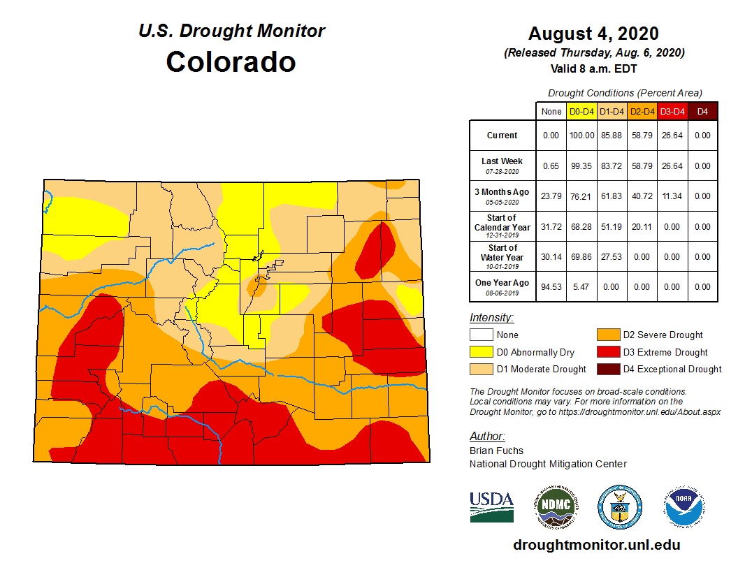
The upshot: As of early August, 100 percent of the state was abnormally dry or in some stage of drought, according to the U.S. Drought Monitor.
Beyond the water supply impacts that farmers and cities might experience in coming months, scientists say that what we saw this spring offers a taste of things to come — thanks to climate change.
And that’s not just a warmer, drier future. Climate change may already be making traditional ways of managing drought and allocating water less reliable. Among these management tools are ones used by water managers to predict what conditions will be like in just a matter of months.
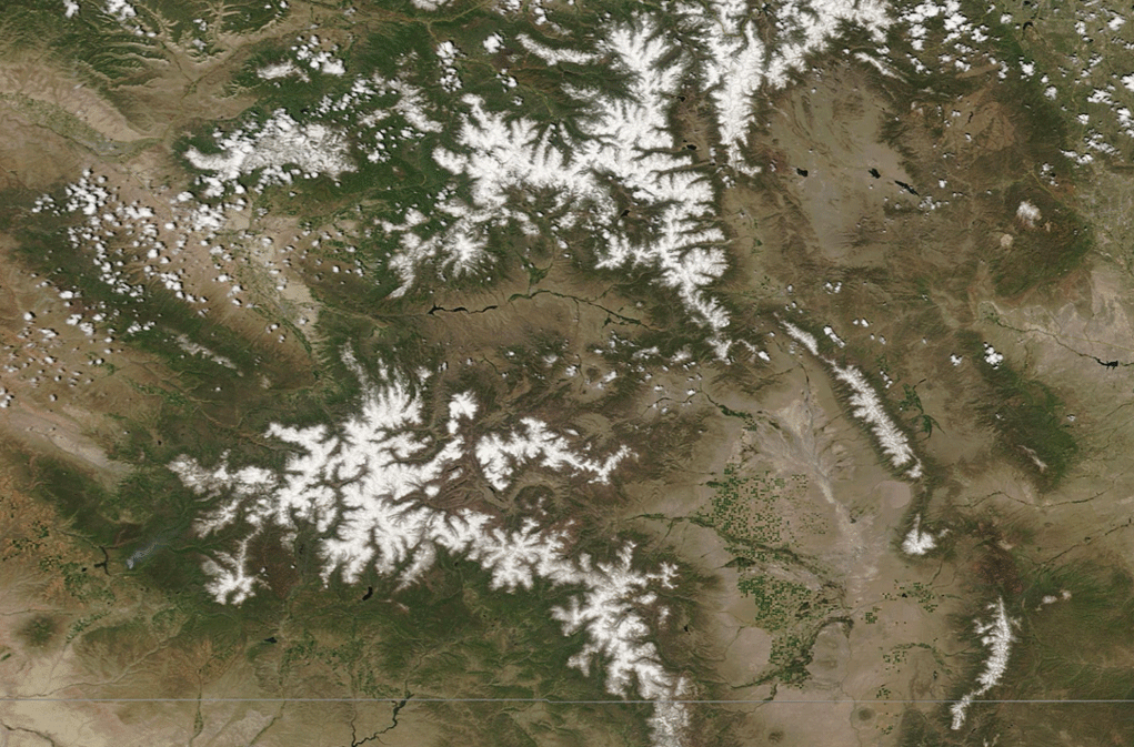
A comparison of images acquired by NASA’s Terra satellite shows how much less snowpack was left in the Colorado Rockies on June 8 of this year compared to the same date last year. It’s a comparison of extremes, with much higher than average snowpack in 2019 and significantly below average now. (Credit: Images via NASA Worldview; animation by Tom Yulsman)
The spring of 2020 offers a telling example. Thanks to the warm and dry conditions, much less water rushed into many of Colorado’s streams and rivers than water managers had forecast at the end of the winter using their traditional tools, which depend heavily on measuring the snowpack in the mountains.
Thankfully, conservation and water stored in reservoirs can see us through relatively short periods of scarcity. But over the longer run, we could find ourselves at risk of seeing our water safety net drop dangerously low.
“Global warming fundamentally changes the hydrological cycle,” says Brad Udall, senior water and climate scientist at Colorado State University’s Colorado Water Center. “Anything water managers relied on in the 20th century is not going to be applicable in the 21st.”
The reality on the ground
With the notable exception of the particularly dry Upper Rio Grande River Basin, most reservoir levels in Colorado were near average as of June 1, according to the most recent water supply outlook report from the Natural Resources Conservation Service. That was thanks mostly to an impressive bounty of snow during the winter and spring of 2019.
That banked water is already proving useful to Northern Water, a public agency that manages an elaborate system for collecting water on the wetter western side of the Colorado Rockies, and piping it under the mountains for use by farmers, cities and industries on the drier eastern side. Farmers in particular rely on that water to meet the needs of their late-season crops. But with the warm and dry spring, they needed extra water earlier in the season than usual.
“This project is about delivering late season water so crops can create full maturity and full yield by end of summer,” says Jeff Stahla, public information officer at Northern Water. But that’s not what has happened so far in 2020. “Farmers were starting to take their water earlier than they wanted to this year because of lack of storms.”
Northern Water’s mission “is different from others in the American West,” he notes. It is “to smooth out the peaks and valleys of the hydrology of northeastern Colorado.”
That mission is particularly important in years like this one, when runoff projections were off across much of Colorado. For example, in early March, forecasters predicted that the Upper Colorado River would swell with enough snowmelt to run at 104 percent of normal during the spring runoff season. Fast forward to early June, and the forecast had to be slashed to just 72 percent of normal.
Further downstream, the runoff flowing through the Colorado River into Lake Powell has fallen way short of expectations, which were pessimistic to begin with. In May, forecasters predicted that river flows into the giant reservoir would total just 65 percent of average through late July. As of the second week of the month, however, the actual inflow into Lake Powell, which serves as a critical hydrological savings bank for 40 million people, was much worse: just 54 percent of average.
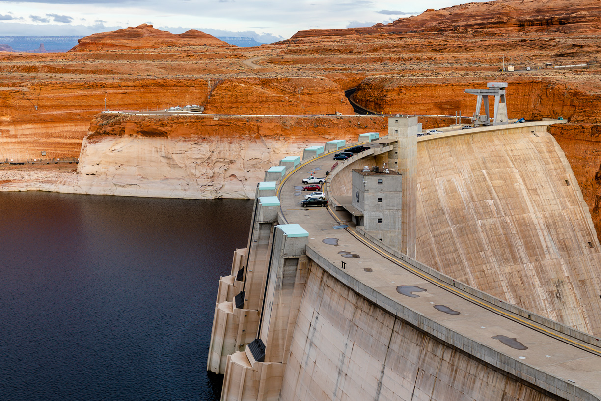
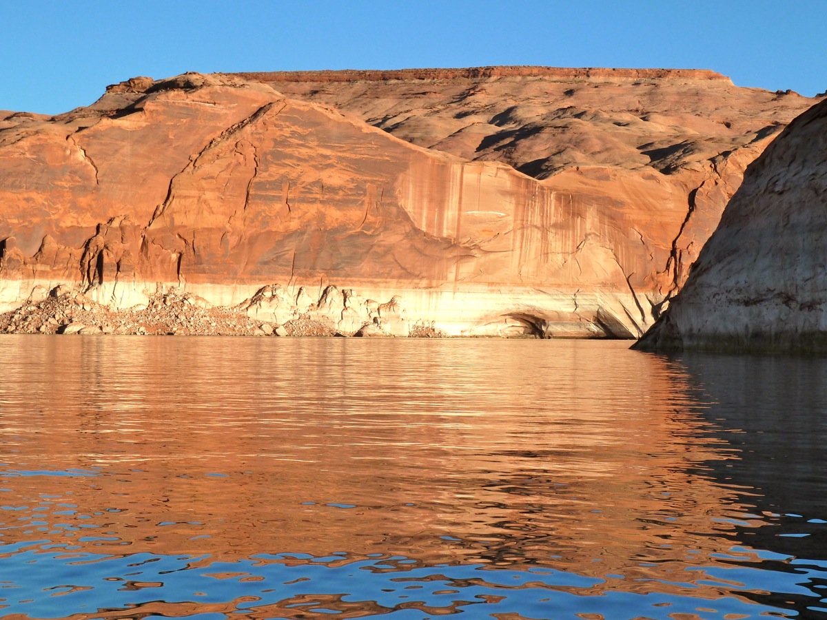
Glen Canyon Dam with the bathtub ring above Lake Powell showing the level it can reach when full. Credit: Mitch Tobin, The Water Desk
That’s been a familiar story over the past 20 years. Stubborn drought in the Colorado River Basin, plus the need to send water to Lake Mead, its sibling reservoir downstream, have left Powell significantly depleted. On July 10, the reservoir was at just 53 percent of capacity, with outflows surpassing inflows.
With so little water, if you were taking a dip there in July, you’d be swimming 90 feet below the surface level of the lake when it is at full capacity. And you’d be looking up at the now infamous “bathtub ring,” a conspicuous white band lining the surrounding cliffs that marks where the water once stood.
Luckily, the epic snowpack of the 2018/2019 winter left the state of Colorado with that nice safety net. Even so, going into last winter, unusual warmth and lack of precipitation caused soils to get extremely dry, part of a trend highlighted by water experts like Udall. This is one of the main factors that is making it increasingly difficult for forecasters to accurately predict how much water would make its way into the system instead of being sucked up by thirsty trees and soil, or evaporating into the warm air.
With above average temperatures continuing to be seen in Colorado and many other parts of the West this summer, the same pre-winter dry-out that occurred last year could well be repeated this year — with impacts possibly extending into next.
Over the longer run, many studies have shown that climate change is already altering the water cycle in the West. For example, annual maximum snowpack in a significant portion of the Western United States — equivalent in size to South Carolina — declined by an average of around 40 percent over the 34 years between 1982 and 2016. In many parts of the West, warming temperatures have also raised the snowline, where precipitation turns from rain to snow, leaving more soil exposed. The snow that does accumulate is also tending to melt out more quickly as spring temperatures arrive earlier due to climate change. The upshot: more drying of soils.
One factor affecting parts of the southern Rockies in particular is a phenomenon called the Hadley cell, a circulation pattern arising in the tropics that affects weather far afield. As part of the phenomenon, air heats up and rises near the equator and flows northwards and southwards high above Earth’s surface. It then descends in the subtropics, in the process warming and drying areas at the surface and thereby helping to sustain deserts like the Sahara and Mohave. From these regions, the air finally returns toward the equator near the surface to complete a giant loop.
Under the influence of climate change, the planet’s Hadley cells are now expanding poleward, according to Udall. This is in turn helping to shift storm tracks northward, and drying out increasingly higher latitude regions — southern Colorado among them.
“You should be nervous if you’re in Durango,” Udall says.
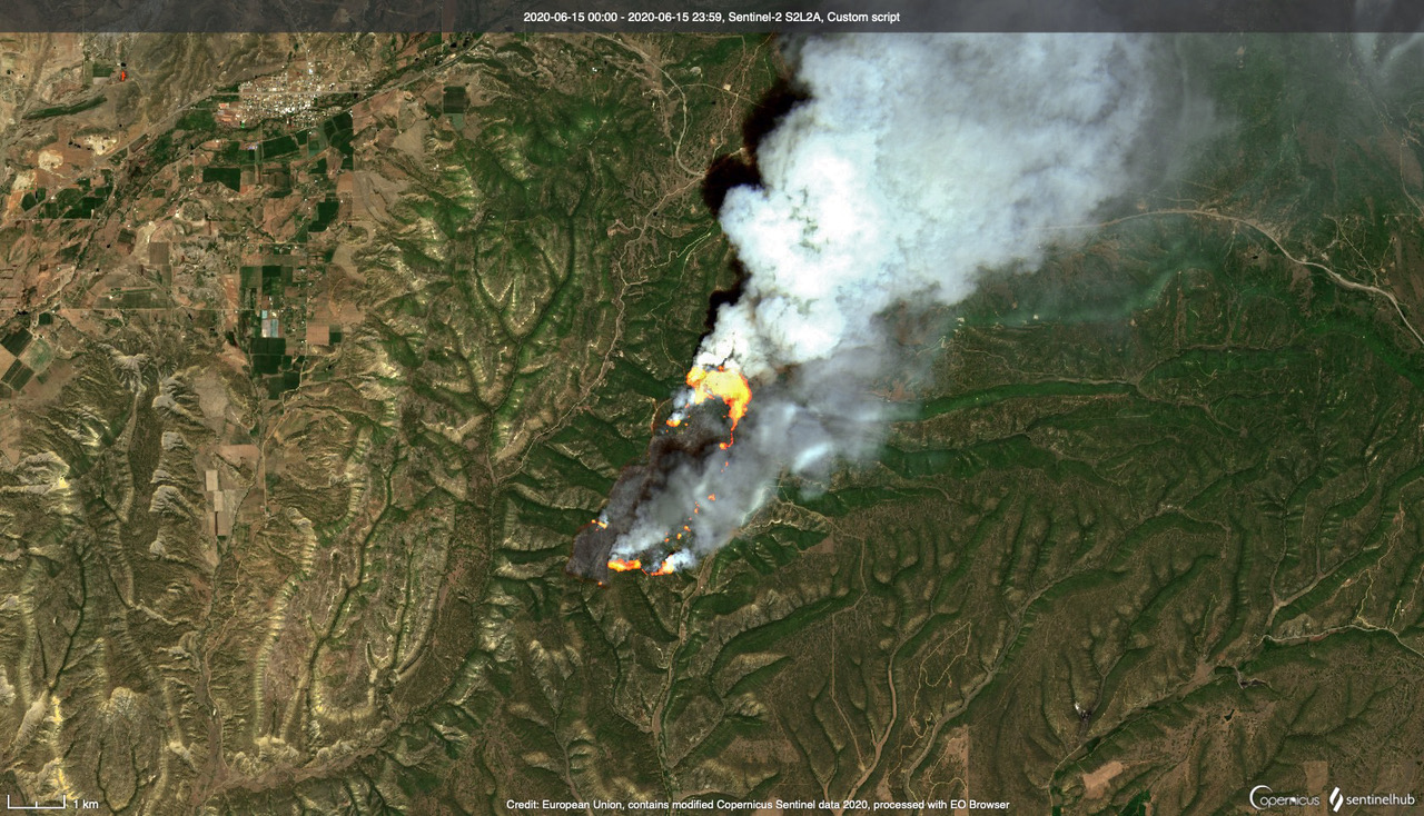
Southwestern Colorado’s East Sentinel Fire burns about 17 miles west of the city of Durango in hot and dry conditions on June 15, 2020, as seen by the Sentinel 2 satellite. (Credit: modified Copernicus Sentinel data processed by Tom Yulsman)
In that part of the state, unusually warm and dry conditions this spring have raised risks of wildfire. In fact, lightning striking a dry pinyon-pine forest near Durango on June 15 sparked the East Canyon Fire. Six days later, it had spread across nearly 3,000 acres, and forced the evacuation of over 35 homes. Luckily, calmer winds allowed firefighters to bring it under control, though nearly 10 new fires were kicked up in the Durango area after more lightning hit the dry region at the end of the month.
For a time this past winter, snowpack in the southern river basins of Colorado was running more or less at average. But it peaked about 10 days earlier than the historical average and melted out rapidly under record-high temperatures in late April. Not surprisingly, these areas of Colorado are the very regions now in the red zone of extreme drought.
To the north, the Upper Colorado River Basin’s snowpack actually peaked later than normal this year. But once again, warm and dry conditions then took a toll: The snowpack went into freefall during April.
Thick snowpack no longer promises brimming reservoirs
Understandably, many people look at the health of the winter snowpack and think the ensuing flows in rivers will be directly proportional, with big powder days a harbinger of an exciting whitewater rafting season to come. However, if the snowpack peaks and melts early, there is more time for exposed land to become dry, which means thirstier plants and soil, which means less water making its way into streams and rivers.
Of course, there are still plenty of big storms and anomalies, like 2018/2019’s bountiful snowpack. But as we saw this past winter, it didn’t save us from the broader, longer-term trend of warming and drying. And that trend can be self-reinforcing.
“Dry soil from one year is a memory in the system for the next year,” Udall says.
A comparison vegetation moisture values centered on Gunnison, Colorado, as measured by the Sentinel 2 satellite in July of 2019 and this year. Red colors indicate drier conditions. (Credit: Copernicus Sentinel data processed by Tom Yulsman)
In his view, what we’re seeing now in Colorado and much of the American Southwest is likely not just a temporary drought that will be eased with more precipitation. The dramatic impact that excessive warmth has had on the crucial springtime flows of runoff in the region’s rivers is part of a phenomenon he and other experts are calling “aridification.”
This is layered on top of the natural ups and downs of climate, in which periods with a dearth of precipitation come and go from year to year. But thanks to the huge amount of heat-trapping carbon dioxide we’ve already emitted into the atmosphere, temperatures will continue to rise in coming years. With that in mind, expectations should shift toward a new baseline of increasing dryness in the already arid West, Udall says.
In fact, a study published in the journal Science this April found that human-caused global warming seems to have pushed the southwestern portion of North America — a region encompassing most of Colorado — into a multi-decadal megadrought, the severity of which hasn’t been seen since the 1500s. Without global warming, the drought, which began in 2000, would likely have been only moderately severe, according to the study.
Aridification, and the possibility of surprises in store as climate change progresses, should prompt us to change how we manage water, Udall argues. In the Colorado River Basin, for example, water management plans typically stay in place for about two decades, and then they get revisited. “I think we’re going to have to revisit these plans more often, and expect them to change in ways we can’t foresee,” he says.
Drought predictability is melting away
If this past winter and spring has shown us anything it is that relying mostly on snowpack to predict drought and water shortages arising from it can lead forecasters astray. And new findings by Ben Livneh, a University of Colorado hydrology researcher, and a colleague show this problem is likely to get worse as warming continues, causing snowpack to shrivel and drought predictability to melt away with it.
The study, published in Nature Climate Change in April, found that if emissions of heat-trapping carbon dioxide continue at high levels, by mid-century forecasters will have a much tougher time predicting seasonal drought across nearly 70 percent of the Mountain West, where snowmelt dominates the water supply. That’s for a simple reason: With more warming, there will be less and less snowpack, and thus less of the stuff essential to the current way of making predictions.
Because of its particularly tall mountains, Colorado likely will fare better than the Pacific Northwest, where the lower elevation and proximity to the ocean puts it at risk of much faster declines in snowpack, according to Livneh. But if emissions continue at high levels, by the end of the century even lofty areas like Colorado could see significant declines in snowpack that would degrade forecasters’ ability to predict drought. Water managers can try to do better in coming years by updating their toolbox with such things as measurements of soil moisture, rainfall and temperature. Satellite observations of snowpack at mountaintops — where ground measurements often are just too difficult to make, and where snow will persist longer — could also prove useful..
Another new approach has already been rolled out in Colorado and California: airborne measurements of the depth and water content of snow in the mountains. In the current approach, relatively sparse measurements of snowpack taken on the ground are compared with the historical record to predict runoff. The basic idea is that since certain snowpack conditions produced a given amount of runoff in the past, they’ll do so again now. But this isn’t working as well as it once did because climate change has, in effect, changed the rules of the game. According to Jeffery Deems, a research scientist with the National Snow and Ice Data Center, and co-founder of Airborne Snow Observatories, measuring snowpack from the air provides a much more complete picture of snowpack in, say, a particular watershed. Forecasters can then use that information along with with other data to model how much runoff is likely to occur, providing a more reliable prediction.
With warming, drying and earlier melt-out of snowpack, water managers are already having to grapple with significant change. Stahla of Northern Water is confident in the ability of his program to adapt — and also to heed the warning these trends are offering about the future.
As he puts it, “If you’re not concerned then you’re probably not looking at the data closely enough.”
Jenna Sampson is a freelance environmental journalist and contributor to The Water Desk. You can find her on Twitter @jennadawn. Tom Yulsman contributed to this story.
The Water Desk has launched a new podcast with in-depth conversations about water issues.
Water Buffs will feature interviews with leaders and experts who can explain the challenges confronting our water resources—and potential solutions. We’ll be talking to journalists, scientists, advocates, policymakers, water users and other stakeholders.
The podcast will also include a regular series, Water Words, that explains important terminology in the water world so that our audience can learn more about these critical topics.
How we chose the name
We chose the name Water Buffs for three reasons:
The podcast will focus on interviews with leading figures in the field, a group that’s often referred to as “water buffaloes”
Our show will feature conversations with experts (aka “buffs”) and we hope to help our audience “buff up” on their own water knowledge
We’re based at the University of Colorado Boulder, where our mascot is a buffalo, students are nicknamed “buffs,” and the official cheer is “Go Buffs!”
We’re creating both audio and video versions of the podcast. You can find Water Buffs on YouTube, Vimeo, Stitcher, iTunes and other platforms.
Interested in appearing? Get in touch.
If you’re interested in appearing on the show, please contact Water Desk Director Mitch Tobin at mitchtobin@colorado.edu.
Special thanks to the executive producer and co-manager of the Water Buffs podcast, Hannah Leigh Myers, and our graphic designer and co-developer Geoff McGhee.
In our first episode, we talk to Geoff about how journalists and others can use maps, graphics, charts and other data visualizations to tell stories about water.
In our first Water Buffs podcast episode, we talk to data visualization expert @mcgeoff about how journalists and others can use maps, charts and graphics to tell stories about water.https://t.co/aUWMldfXfv
Should Colorado River water be used to grow alfalfa or subdivisions in the Phoenix metropolitan area? A pending water sale pits communities along the river against those of Queen Creek, population 50,000 and is setting the stage for future battles over the world’s most precious resource.
Producer/Editor: Vanessa Barchfield
Videographer: Jeff Landers, Martín Rubio
Editor: Mya Hoffman-Long
This story was supported by a grant from The Water Desk, an independent journalism initiative based at the University of Colorado Boulder’s Center for Environmental Journalism.
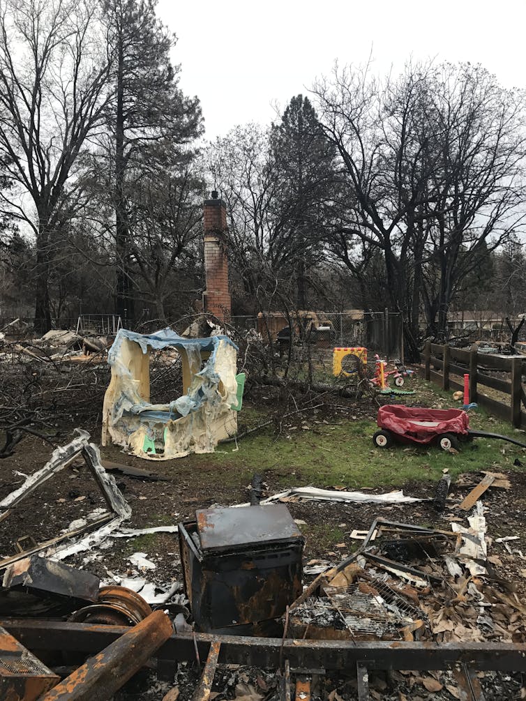
In recent years wildfires have entered urban areas, causing breathtaking destruction.
The 2018 Camp Fire in Paradise and Butte County, California was the deadliest and most destructive fire in California’s history. It took 86 lives and destroyed more than 18,000 structures in a matter of hours.
Almost two years later, only a fraction of the area’s 40,000-plus population has returned. This disaster followed the 2017 Tubbs Fire, which killed 22 people in California’s Sonoma and Napa counties.
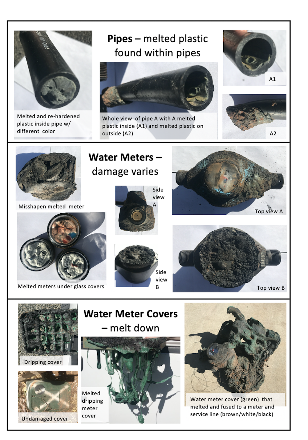
After both fires, drinking water tests revealed a plethora of acutely toxic and carcinogenic pollutants. Water inside homes was not safe to use, or even to treat. Water pipes buried underground and inside of buildings were extensively contaminated.
We are environmentalengineers who help communities affected by disasters, and supported responses to both fires. As we conclude in a recently published study of burned areas, communities need to upgrade building codes to keep wildfires from causing this kind of widespread contamination of drinking water systems.
Survivors left everything to flee the Camp Fire’s path. Andrew Whelton, Purdue University
Wildfires and water
Both the Tubbs and Camp fires destroyed fire hydrants, water pipes and meter boxes. Water leaks and ruptured hydrants were common. The Camp Fire inferno spread at a speed of one football field per second, chasing everyone – including water system operators – out of town.
After the fires passed, testing ultimately revealed widespread hazardous drinking water contamination. Evidence suggests that the toxic chemicals originated from a combination of burning vegetation, structures and plastic materials.
Firefighting can accelerate the spread of contamination. As emergency workers draw hydrant water, they spread contaminated water through the water pipe network.
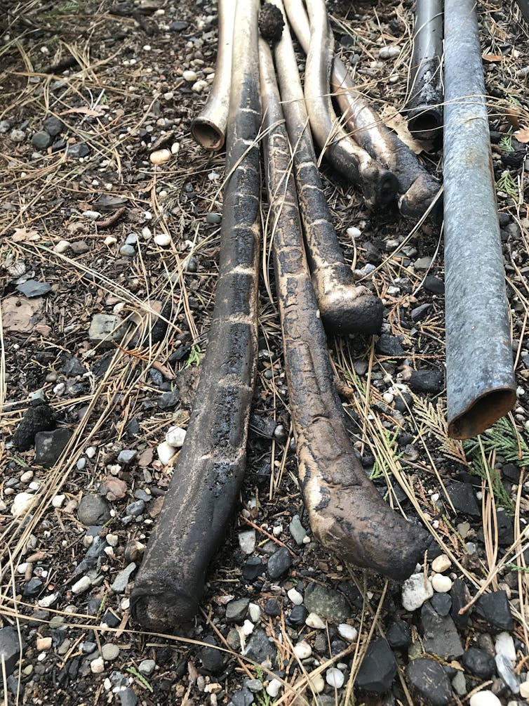
Metal, concrete and plastic pipes can become contaminated. Many plastics take up these chemicals like sponges. As clean water later passes through the pipes, the toxic substances leach out, rendering the water unsafe.
In the Tubbs and Camp fires, chemicals in the air may have also been sucked into hydrants as water pipes lost pressure. Some water system plastics decomposed and leached chemicals directly into water. Toxic chemicals then spread throughout pipe networks and into buildings.
Limited water testing by state and local agencies showed benzene and naphthalene were present at levels that could cause immediate harm. These, as well as methylene chloride, styrene, toluene and vinyl chloride exceeded longer-term regulated exposure limits. Many of these chemicals cause cancer. All can cause vomiting, diarrhea and nausea after short-term high concentration exposure.
Anyone who drinks the water containing these substances could be harmed. And simply running a faucet could cause chemicals to enter the air. Hot showers and boiling water would vaporize the chemicals and increase the dose a person breathed in. Some of these substances can also be absorbed through the skin.
Dangerous contamination levels
Benzene was found at concentrations of 40,000 parts per billion (ppb) in drinking water after the Tubbs Fire and at more than 2,217 ppb after the Camp Fire. According to the California Office of Environmental Health Hazard Assessment, children exposed to benzene for a single day can suffer harm at levels as low as 26 ppb.
The U.S. Environmental Protection Agency recommends limiting children’s short-term acute exposure to 200 ppb, and long-term exposure to less than 5 ppb. The EPA regulatory level for what constitutes a hazardous waste is 500 ppb.
In early 2019, California conducted contaminated water testing on humans by taking contaminated water from the Paradise Irrigation District and asking persons to smell it. The state found that even when people smelled contaminated water that had less than 200 ppb benzene, at least one person reported nausea and throat irritation. The test also showed that water contained a variety of other benzene-like compounds that first responders had not sampled for.
The officials who carried out this small-scale test did not appear to realize the significance of what they had done, until we asked whether they had had their action approved in advance by an institutional review board. In response, they asserted that such a review was not needed.
In our view, this episode is telling for two reasons. First, one subject reported an adverse health effect after being exposed to water that contained benzene at a level below the EPA’s recommended one-day limit for children. Second, doing this kind of test without proper oversight suggests that officials greatly underestimated the potential for serious contamination of local water supplies and public harm. After the Camp Fire, together with the EPA, we estimated that some plastic pipes needed more than 280 days of flushing to make them safe again.
Plastic pipes can be damaged by heat and fire contact. Andrew Whelton, Purdue University
Building codes could make areas disaster-ready
Our research underscores that community building codes are inadequate to prevent wildfire-caused pollution of drinking water and homes.
Installing one-way valves, called backflow prevention devices, at each water meter can prevent contamination rushing out of the damaged building from flowing into the larger buried pipe network.
Adopting codes that required builders to install fire-resistant meter boxes and place them farther from vegetation would help prevent infrastructure from burning so readily in wildfires. Concrete meter boxes and water meters with minimal plastic components would be less likely to ignite. Some plastics may be practically impossible to make safe again, since all types are susceptible to fire and heat.
Water main shutoff valves and water sampling taps should exist at every water meter box. Sample taps can help responders quickly determine water safety.
Benzene contamination in the water supply slowed rebuilding efforts in Paradise, Calif., after the Camp Fire.
The smell test doesn’t work
Under no circumstance should people be told to smell the water to determine its safety, as was recommended for months after the Camp Fire. Many chemicals have no odor when they are harmful. Only testing can determine safety.
Ordering people to boil their water will not make it safe if it contains toxic chemicals that enter the air. Boiling just transmits those substances into the air faster. “Do not use” orders can keep people safe until agencies can test the water. Before such advisories are lifted or modified, regulators should be required to carry out a full chemical screen of the water systems. Yet, disaster after disaster, government agencies have failed to take this step.
While infrastructure is being repaired, survivors need a safe water supply. Water treatment devices sold for home use, such as refrigerator and faucet water filters, are not approved for extremely contaminated water, although product sales representatives and government officials may mistakenly think the devices can be used for that purpose.
To avoid this kind of confusion, external technical experts should be called in assist local public health departments, which can quickly become overwhelmed after disasters.
The damage that the Tubbs and Camp fires caused to local water systems was preventable. We believe that urban and rural communities, as well as state legislatures, should establish codes and lists of authorized construction materials for high-risk areas. They also should establish rapid methods to assess health, prepare for water testing and decontamination, and set aside emergency water supplies.
Wildfires are coming to urban areas. Protecting drinking water systems, buried underground or in buildings, is one thing communities can do to prepare for that reality.
Update: this deadline is now passed. Thanks for your interest in our grant programs. To stay up to date, follow us on Twitter and subscribe to our email newsletter.
The Water Desk is now accepting applications for grants to support coverage of Western water issues and the Colorado River Basin.
We are offering two grantmaking programs:
1) Standard grants of up to $10,000. The standard grants support in-depth reporting efforts that lead to the publication or broadcast of content. The deadline for applications for the 2020 standard grants is August 17. We anticipate announcing recipients of the standard grants in mid-September.
2) Micro-grants of up to $2,000. These are meant to pay for discrete expenses that are necessary to produce content or advance a journalist’s professional development. Applications for micro-grants will be reviewed on a rolling basis. We plan to make decisions on micro-grant applications within one month of their submission.
The geographic scope of our grantmaking includes Arizona, California, Colorado, Nevada, New Mexico, Utah, Wyoming and the borderlands of Northwest Mexico.
We welcome proposals from journalists and outlets representing a wide range of media: newspapers, magazines, websites, video, television, radio, podcasts and other channels.
Because water is intertwined with so many issues, we are open to proposals covering a broad spectrum of topics, including climate change, biodiversity, pollution, public health, environmental justice, food, agriculture, drinking water, economics, recreation and more.
Questions? Please feel free to contact Susan Moran, a consultant to The Water Desk, at susan.moran@colorado.edu.
The bathtub ring in Lake Powell in October 2014, which illustrates how reservoir levels have dropped since 2000. A state official says she sees no reason Colorado shouldn’t move forward with an investigation of a program that would send water to Lake Powell. Photo by Brent Gardner-Smith/Aspen Journalism.
After a year of meetings, workshops and in-depth discussions, state officials feel a feasibility investigation into a program that would pay water users to reduce consumption and add to a savings account in Lake Powell should continue.
Although no formal decision has yet been made on whether to implement a voluntary, temporary and compensated water-use reduction plan known as demand management, Amy Ostdiek, Colorado Water Conservation Board deputy section chief for interstate, federal and water information, told the state agency’s board of directors on Wednesday she has not found a reason to keep from moving forward.
“I didn’t identify any points that would indicate to me that we should stop the feasibility investigation,” said Ostdiek, who has been leading and organizing the process for the state. “From my perspective, we have not identified a reason not to continue the analysis or any hard reason it wouldn’t work.”
At the heart of a potential program is a reduction in water use in an attempt to send up to 500,000 acre-feet downstream to Lake Powell to bolster levels in the giant reservoir and meet 1922 Colorado River Compact obligations.
Under such a program, agricultural water users could get paid to temporarily fallow fields and leave more water in the river, in order to fill a 500,000 acre-foot pool as an insurance policy in case of continued drought or further reduction in average flows.
This field near Carbondale is irrigated with water that eventually flows into the Colorado River. The state has wrapped up the first year of an investigation into a program that could pay irrigators to reduce their consumptive use in order to send water downstream to a savings account in Lake Powell. Photo by Heather Sackett/Aspen Journalism.
Report from workgroups
In June 2019, the CWCB, a state agency responsible for developing and protecting Colorado’s water, named 74 water experts and managers to eight work groups tasked with tackling complicated issues and questions around the creation of a demand management program. The groups were divided by topics: law and policy; monitoring and verification; water-rights administration and accounting; environmental considerations; economic considerations and local government; funding; education and outreach; and agricultural impacts.
A ninth group, headed by former Colorado lawmaker and chair of the Interbasin Compact Committee Russell George, has been focusing on how to ensure a demand management program is equitable among water users and basins. The IBCC facilitates conversations among representatives of different river basins and addresses statewide water issues.
Each group met multiple times over the past year and their findings, as well as their lingering questions, were included in a 200-page demand management update report presented Wednesday to CWCB directors.
The sprawling report summarizes the work completed by the groups and their overlapping key values, concerns and uncertainties. The sustainability of agriculture and agricultural communities ranked highest in the values category, while program design and participation ranked highest in the uncertainties category.
Several board members offered their opinions on a potential demand management program. Steve Anderson, who represents the Gunnison-Uncompahgre River basin, questioned whether the state could create water savings by funding more projects outlined in the Basin Implementation Plans instead of crafting a demand management program. The BIPs identify how each basin’s water needs will be met through existing or new projects, policies and processes.
“Once we become more efficient I think we would generate more system water for the Colorado,” he said. “At the end of the day we are going to have a choice between buying an insurance plan or using those funds elsewhere for conservation and efficiency.”
It is unclear how much a demand management program would cost the state, but one of the work groups is dedicated to the funding question.
The main goal of a demand management program would be to defend against what’s known as a “compact call,” which could happen if the upper basin states — Colorado, Utah, Wyoming and New Mexico — were not able to deliver the 75 million acre-feet of water over 10 years to the lower basin states, as required by the Colorado River Compact. Colorado water managers desperately want to avoid this scenario, which looms larger each year with the increasing effects of drought and climate change on an over-allocated river, because it could trigger mandatory cutbacks for water users.
CWCB board member Greg Felt, who represents the Arkansas River basin, struck a dark tone, saying moving forward with a demand management program is necessary because one of the potential alternatives — involuntary cutbacks, also known as “curtailment” under a compact call — will be impossible to enforce.
“I frankly think that people are not going to accept curtailments on any rights the way they have historically,” Felt said. “From what I’ve watched this year in rural Colorado, people aren’t going to be buying curtailment. The water is going to come out of the stream. You can’t have enough water commissioners to stop that.”
Water from the Government Highline Canal pours into Highline Lake in Mack. If irrigators in Grand Valley need more water than what was supplied upstream, the Grand Valley Water Users Association – the group that regulates water flow in the canal – can close the gate to the lake to back up water as a last resort. Photo by Bethany Blitz/Aspen Journalism.
Funding for next steps restored
With the first year of a feasibility investigation complete, the ultimate decision on whether to move forward with a demand management program lies with CWCB board members. The board plans to discuss the work presented by the work groups at a one-day workshop in September.
CWCB staff also are planning a virtual regional workshop for the public to learn more about the first year’s findings. Both meetings will be open to the public.
For several weeks there was uncertainty surrounding the future funding of the demand management feasibility investigation, when on May 1, Gov. Jared Polis suspended the program’s funding due to the COVID-19-caused state budget crisis. But the funding was restored in this year’s projects bill, according to CWCB Deputy Director Lauren Ris.
The agency now has until the end of June 2021 to spend the remaining $834,000 of the original $1.7 million allocation, should the board decide to continue delving into the issue for another year.
CWCB Director Rebecca Mitchell urged the board to be leaders for Colorado on the issue of demand management.
“We want to do whatever we can to avoid a curtailment situation,” Mitchell said. “Everyone is looking to see what we do and how we handle this, and we do have a very unique opportunity at a very critical time to lead strongly on this.”
Aspen Journalism is a local, nonprofit, investigative news organization covering water and rivers in collaboration with The Aspen Times and other Swift Communications newspapers. This story ran in the July 18 edition of The Aspen Timesand the July 19 edition of Aspen Journalism.
Out of sight and out of mind to most people, the Salton Sea in California’s far southeast corner has challenged policymakers and local agencies alike to save the desert lake from becoming a fetid, hyper-saline water body inhospitable to wildlife and surrounded by clouds of choking dust.
The sea’s problems stretch beyond its boundaries in Imperial and Riverside counties and threaten to undermine multistate management of the Colorado River. A 2019 Drought Contingency Plan for the Lower Colorado River Basin was briefly stalled when the Imperial Irrigation District, holding the river’s largest water allocation, balked at participating in the plan because, the district said, it ignored the problems of the Salton Sea.
“The Salton Sea has to be acknowledged for what it is — a serious public health and environmental crisis that can and will have long-term, devastating consequences across the region,” said Norma Galindo, president of the irrigation district’s board of directors. “It is an indispensable part of the Colorado River system, not an invisible one. Its decline simply must be addressed.”
The Salton Sea “is an indispensable part of the Colorado River system, not an invisible one. Its decline simply must be addressed.” ~ Norma Galindo, Imperial Irrigation District board president
The state of California, long derided for its failure to act in the past, says it is now moving full-bore to address the sea’s problems, with ambitious plans for wildlife habitat expansion and dust suppression.
“We are moving as fast as we can and are fully committed to doing the really good things that we need to be doing at the Salton Sea to address the real issues down there,” said Arturo Delgado, assistant secretary for Salton Sea policy at the California Natural Resources Agency.
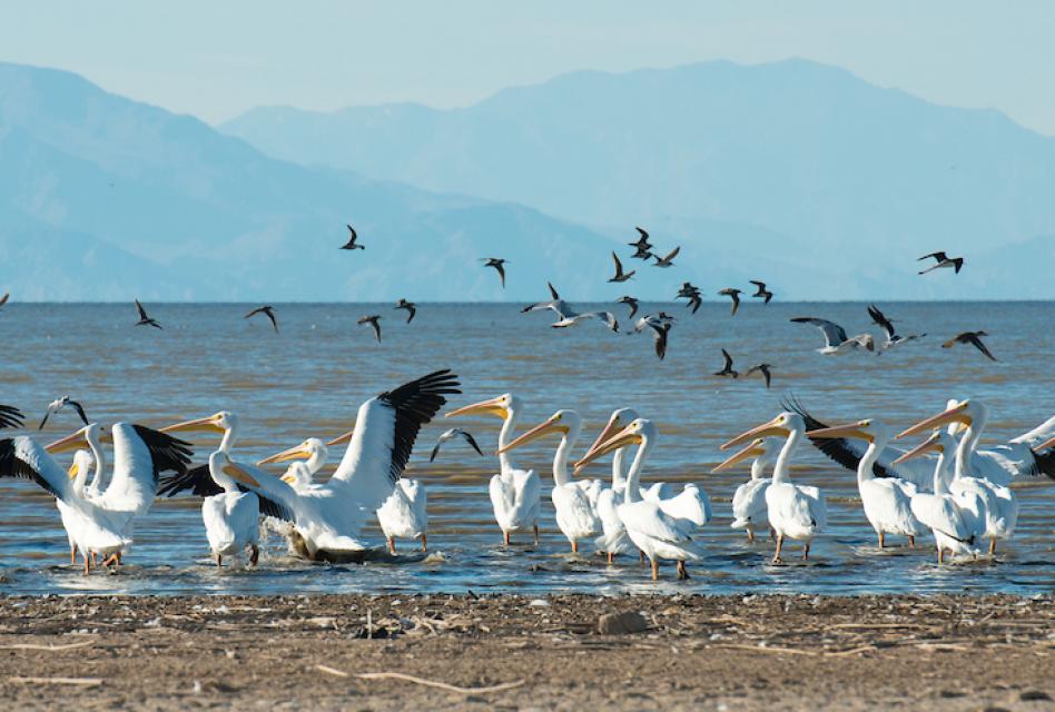
Agencies with a stake in the Salton Sea are racing to cope with twin problems: suppressing dust from the sea’s receding shoreline to protect the small communities that ring the lake while enhancing areas that are essential to fish and birds. In a state where more than 90 percent of historic wetlands have been lost, the Salton Sea is a vital stop for birds along the migratory route of the Pacific Flyway. All told, more than 400 bird species make regular use of the Salton Sea.
A question of urgency
As California’s largest lake, the Salton Sea is unique. More than 230 feet below sea level, it has no natural outlet and is twice as salty as ocean water. For about 20 years, the sea’s water level has steadily declined, further concentrating the salinity.
Rising salinity levels have had a detrimental impact on wildlife at the Salton Sea. (Source: California Department of Water Resources)
Protecting and restoring the sea’s ecological values has been a longtime aspiration, but progress has been achingly slow. State plans, some of them ambitious in scope, have come and gone while the sea deteriorates.
“There is no sense of urgency,” said Frank Ruiz, Salton Sea program director with Audubon California. “The Salton Sea has never been a priority for the state or any other entity outside the area.”
Gov. Gavin Newsom’s administration has pledged to make progress. Getting there includes the laborious tasks of siting, designing and building dust suppression and habitat projects and convincing skeptical locals that inroads will be made where other efforts have fallen short. The state has set the lofty goal of creating 30,000 acres of habitat and dust suppression by 2028.
Delgado said he and his colleagues are up to the challenge.
“When I came in eight months ago, we took stock of our current situation and started developing a realistic timeline based on when we could possibly complete this work,” he said. “It’s a very aggressive timeline but it’s doable.”
Frank Ruiz, Salton Sea program director for Audubon California, has decried the pace of work at the Salton Sea. (Source: Audubon California)
The action plan includes working with local partners such as the Imperial Irrigation District, which has long chafed at the pace of progress at the sea. Earlier this year, the state and Imperial Irrigation District completed the Bruchard Road Dust Suppression Project on about 125 acres of exposed playa at the sea’s southern edge.
Imperial Irrigation District opposed participating in a Colorado River Lower Basin Drought Contingency Plan last year because it did not adequately address the sea’s plight. The federal government’s lack of financial commitment to the sea “has been the single biggest impediment to a Lower Basin Drought Contingency Plan that could do what Imperial and all other Colorado River contractors need it to do, which is reduce the risk of reaching critical elevations at Lake Mead,” said Galindo, the district’s board president. Earlier this month, in its legal challenge to the Drought Contingency Plan, the district reaffirmed its view that the drought plan should be suspended until the sea’s environmental needs are assessed.
Making something bad better
Deep furrows are carved into the playa to help suppress blowing dust along the receding shoreline of the Salton Sea. (Source: Imperial Irrigation District)
Imperial Irrigation District signed on to a landmark 2003 water transfer between the district and San Diego, known as the Quantification Settlement Agreement (QSA), to help California reduce its overuse of Colorado River water. One effect of that was a significant curtailment of the Salton Sea’s inflow from farm irrigation. As part of the agreement, the state committed to pursuing a restoration plan for the sea while the district contributed mitigation water through 2017. However, a long-term, comprehensive Salton Sea management program has never fully emerged, due in part to the expense.
The transition from the Gov. Jerry Brown administration to the Newsom administration in 2019 brought renewed focus to the sea. However, tangible results remain elusive, said Tina Shields, Imperial’s water manager.
“When you are 15 years behind, you are not just going to wave a magic wand and suddenly have all of these projects completed,” she said.
Identifying and remedying problem areas can be a checkered process, Shields said. Potential projects often face extensive hurdles. “You’d think it would be easy to permit a mitigation project, something that’s going to make something bad better,” Shields said. “But it’s just as complicated as building a Walmart in Temecula because you have to bring in all of those wetlands permits.”
The state’s plan hinges on near-term and long-term actions that improve all elements of the sea, including evaluation of a possible “whole sea” solution that would import ocean water from the Sea of Cortez to stabilize the Salton Sea. Adding water from a source as reliable as the Pacific Ocean would seem to be an obvious solution, but it’s not that easy.
“It’s all about the salt,” said Phil Rosentrater, executive director of the Salton Sea Authority, the joint powers authority of local leaders that works with the state to revitalize the sea. “Water is certainly a critical part of the equation for a more sustainable sea, but salt management is the difference between life and death for the ecosystem.”
“Everybody in the Western Hemisphere needs to care at one level because it’s an integral and critical part of the Pacific Flyway. If we lose the Salton Sea, we lose one of the last wetlands for migrating birds.” ~Celeste Cantú, former executive director, State Water Resources Control Board
Teed up for work this year are plans by the state to launch 3,800 acres of habitat for the fish-eating birds that are most affected by a crashing sea. Rosentrater said his agency is poised to leverage state investments with federal dollars to work on habitat and dust suppression projects.
Air quality is a significant issue. At times the rotten egg smell caused by the sea’s hydrogen sulfide emissions has spurred complaints from people in Simi Valley, 200 miles away.
Dust suppression is paramount. The sea’s inflow from farm runoff has fallen substantially since 2003, accelerating the sea’s retreat, increasing salinity and exposing more shoreline, especially in the shallower areas. What’s left is a chalky playa that stirs into blinding clouds when the wind blows. The dust is laden with toxic elements, posing further harm to local communities, many of them disadvantaged and already struggling with high asthma rates.
The situation does not sit well with Imperial County, which last year declared a local state of emergency at the sea to address the dust suppression issue. Last month, on June 23, the county’s Air Pollution Control District slapped notices of violation on the U.S. Fish and Wildlife Service and the Imperial Irrigation District for failing to address ongoing dust problems at the sea’s southeastern edge.
Projects to address the problems take time and resources and must navigate the regulatory permitting process. Furthermore, because the state is not a major landowner or water rights holder in the region, it must secure easements and needed water, said Delgado, the Resources Agency official.
The imperiled sea
Situated in an ancient lakebed that naturally filled with Colorado River water on occasion through the centuries, the Salton Sea of today came to life in the early 1900s when river water blew through an irrigation ditch. By the time the flow stopped, it filled a basin 45 miles long, 17 miles wide, and 83 feet deep.
In the 1950s and 1960s, it was touted as a Riviera-like destination for sun lovers and water enthusiasts, but that destiny was short-lived. Since then, the Salton Sea has assumed an other-worldly aura with occasional spikes of foul odor and dead fish.
The Salton Sea’s role as one of the few remaining refuges for migratory waterfowl raises its profile substantially.
“Everybody in the Western Hemisphere needs to care at one level because it’s an integral and critical part of the Pacific Flyway,” Celeste Cantú, former executive director of the State Water Resources Control Board, said in an interview. “If we lose the Salton Sea, we lose one of the last wetlands for migrating birds.”
A native of Calexico in the Imperial Valley, Cantú moderated a panel on the state’s response at the October 2019 Salton Sea Summit.
The state has outlined short-term and long-term actions for the sea, targeting habitat creation and more than 8,000 acres of dust suppression projects by the end of 2022.
Shields, with Imperial Irrigation District, sees both sides of the equation – the state’s efforts and the frustration of local residents tired of inaction.
“I think the state’s making progress,” she said. “The problem is for all the effort they are putting into it now; the general public isn’t going to see that progress for two or three years. Until you get the contractors out there, the trucks moving dirt, they [the general public] don’t get the process behind designing and going out to bid and staffing up.”
The big picture
Since the signing of the QSA, the clock has been ticking at the Salton Sea, which will keep demanding the attention of everyone concerned about and responsible for public health and ecological preservation.
Then there is how the sea will be accounted for in the grander vision of Colorado River management. Imperial Irrigation District hopes the sea “will have a much higher profile and receive the attention it needs in relation to the region’s collective management of the Colorado River,” said Galindo, the district’s board president.
Forging a sustainable path for the Salton Sea is “a must-have,” according to Norma Galindo, president of the Imperial Irrigation District’s board of directors. (Source: Imperial Irrigation District)
Forging a sustainable path for the Salton Sea is “a must-have” for Imperial, Galindo said. She added that the district’s twin goals of being a good citizen on the Colorado River and seeing a sustainable Salton Sea are compatible and “linked together, hydrologically and morally.”
Rosentrater acknowledged the inertia of the past and the difficulties with finding the right solutions. There was a time when people believed the sea’s problems were insurmountable and not worth the investment of time or resources. That’s changed.
“When you get down to it, doing nothing turns out to be the most costly and reckless of all options,” he said. “That was the conversation of a decade ago, let the thing die and stop trying to prop it up. We have come a long way from there to realizing if we let it go, it’s catastrophic.”
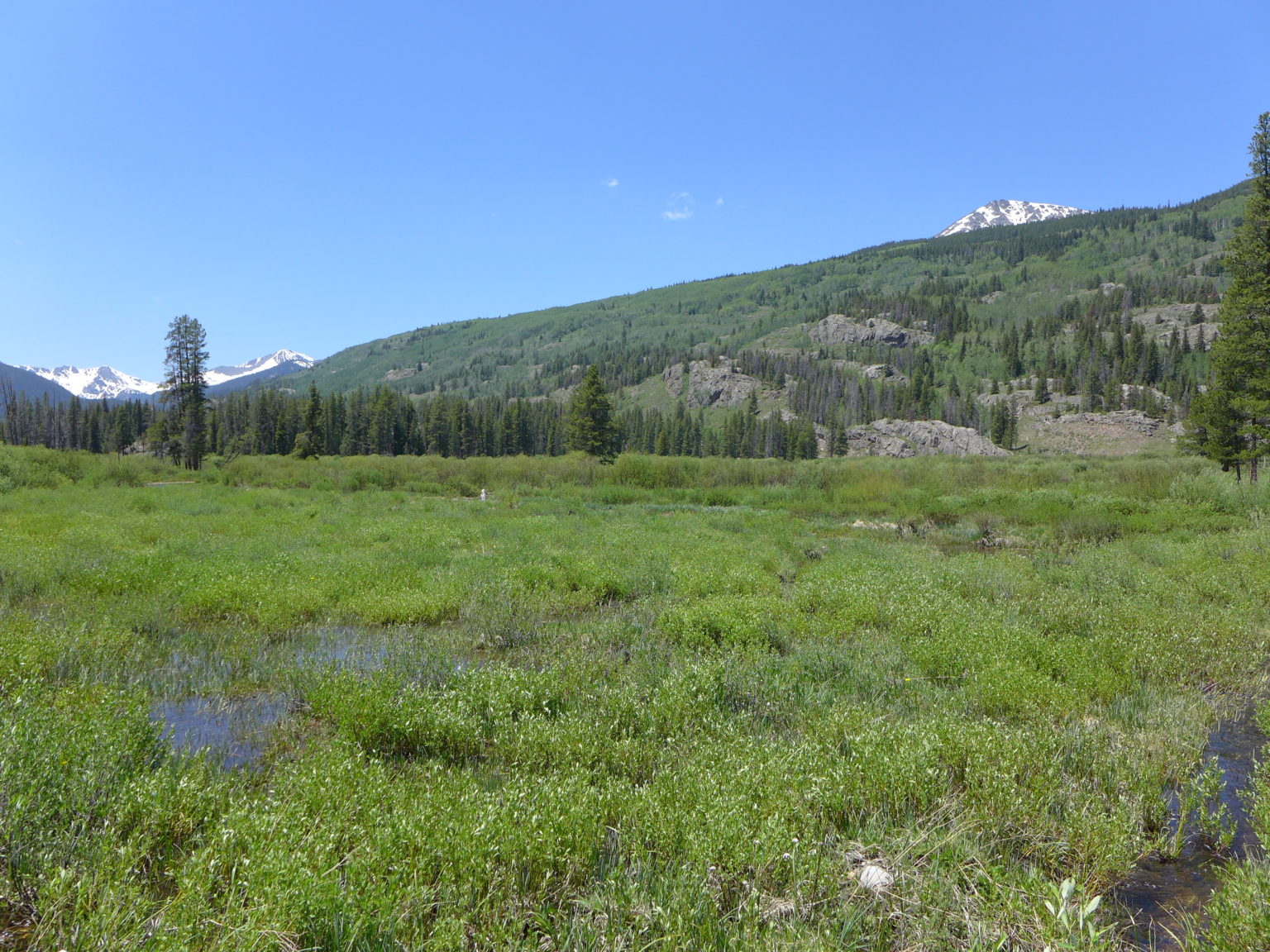
These wetlands, located on a 150-acre parcel in the Homestake Creek valley that Homestake Partners bought in 2018, would be inundated if Whitney Reservoir is constructed. The Forest Service received more than 500 comments, the majority in opposition to, test drilling associated with the project and the reservoir project itself. Photo by Heather Sackett/Aspen Journalism.
By David O. Williams
RED CLIFF — The U.S. Forest Service has been inundated with more than 500 online comments — the vast majority in opposition — to a geophysical study and drilling by the cities of Aurora and Colorado Springs to determine the feasibility of a second reservoir in the Homestake Creek drainage, including objections from nearby towns and a local state senator.
The geophysical study and the drilling are the next step in the lengthy process of developing a reservoir on lower Homestake Creek.
The mayors of Red Cliff and Minturn signed and submitted separate but identical letters questioning the legality of drilling 10 boreholes on Forest Service land near the Holy Cross Wilderness Area, which is six miles southwest of Red Cliff, to see whether soil and bedrock can support a dam for what would be known as Whitney Reservoir. Avon’s attorney has asked for a public comment extension to Aug. 4 so that it can hold a hearing.
“A Whitney Reservoir would irreparably change and harm our community,” Minturn Mayor John Widerman and Red Cliff Mayor Duke Gerber wrote in their letters, submitted June 30. “We are paying close attention to these proposals, other moves by Homestake Partners and the public controversy. This categorical exclusion is rushed, harmful and unlawful.”
Operating together as Homestake Partners, the cities of Aurora and Colorado Springs own water rights dating to the 1950s that, under the 1998 Eagle River Memorandum of Understanding (MOU), give them the basis to pursue developing 20,000 acre-feet of water a year from the Western Slope. They’ve been studying four potential dam sites in the Homestake Valley several miles below the cities’ existing Homestake Reservoir, which holds 43,600 acre-feet of water.
The smallest configuration of Whitney Reservoir, if deemed feasible and ultimately approved, would be 6,850 acre-feet, and the largest would be up to 20,000 acre-feet. The reservoir, on lower Homestake Creek, would pump water up to Homestake Reservoir, about five miles upstream, then through a tunnel under the Continental Divide to Turquoise Reservoir near Leadville.
In 2018, Homestake Partners paid $4.1 million for 150 acres of private land, which it leases back to the former owner for a nominal fee. That land, which would be inundated to accommodate a large portion of Whitney Reservoir’s surface area, is braided with streams and waterfalls and is lush with fens and other wetlands. It’s also home to a cabin once used as an officers quarters for the famed 10th Mountain Division of the U.S. Army. The site is not far from Camp Hale, between Red Cliff and Leadville, where soldiers trained for mountain warfare during World War II.
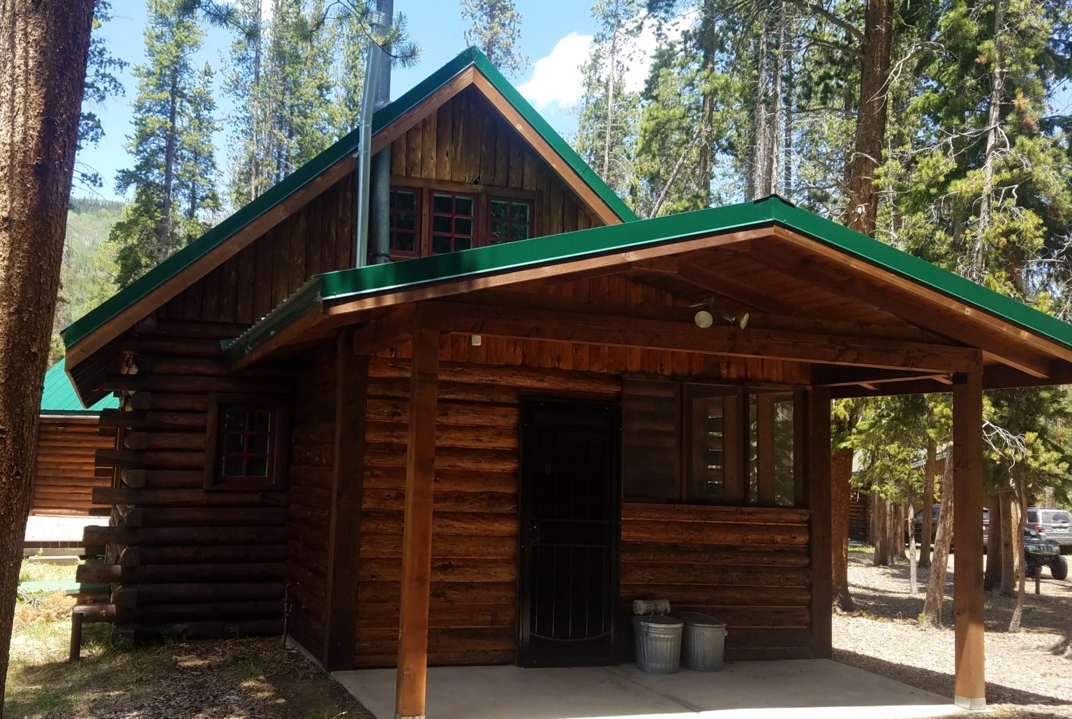
This cabin, once used by the 10th Mountain Division of the U.S. Army, sits on a 150-acre parcel owned by Homestake Partners. The site of the proposed Whitney Reservoir is near Camp Hale, between Red Cliff and Leadville. Photo by David O. Williams/Aspen Journalism.
Eagle River MOU
The Eagle River MOU is an agreement between Aurora and Colorado Springs and a bevy of Western Slope water interests. The Colorado River Water Conservation District, Eagle River Water & Sanitation District, Upper Eagle Regional Water Authority, and Vail Resorts are collectively defined in the MOU as the Reservoir Company. None of those entities submitted comments to the Forest Service on the drilling proposal. And according to Diane Johnson, communications and public affairs manager for the ERWSD and UERWA, none are helping to pay for the feasibility study and none are involved in the reservoir project, except to the degree that it is tied to the MOU.
The MOU provides for 20,000 acre-feet of average annual yield for the cities. “Yield” refers to a reliable supply of water. In some cases, yield equates to storage in a reservoir, but yield can also be created by other methods, such as pumping water uphill from a smaller, refilled reservoir, which is an option being studied by the cities on lower Homestake Creek. The MOU also provides for 10,000 acre-feet of “firm dry year yield” for the Western Slope entities in the Reservoir Company, and firm dry year yield means a reliable supply even in a very dry year. Those entities have developed about 2,000 acre-feet of that allocated firm yield in Eagle Park Reservoir, and it’s not yet clear whether the Whitney Reservoir project would help them realize any additional yield.
“The short answer is we support (Homestake Partners’) right to pursue an application for their yield,” Johnson said. “We trust the permitting process to bring all impacts and benefits to light for the community to consider and weigh in total.” .
Jim Pokrandt, director of community affairs for the River District, declined to comment on the investigatory test work, saying only, “Yes, we have signed the MOU. That said, … we are not participating in the Whitney Creek effort.”
Besides Homestake Partners and the Reservoir Company, the MOU was signed by the Climax Molybdenum Company. The two private companies signed onto the MOU — Vail Resorts and Freeport-McMoRan (Climax) — also declined to comment on either the drilling study or Whitney Reservoir.
Under the MOU, various parties can pursue projects on their own, and the other parties are bound to support those efforts, but only to the degree that a proposed project meets the objectives of the MOU, including whether a project “minimizes environmental impacts.”
Many of the 520 online comments as of the June 30 deadline objected to testing for the possibility of a dam, expressing concern for the complex wetlands in the area, but most of the comments also strongly condemn the overall project: a potential future Whitney Reservoir.
The cities are trying to keep the focus on the test drilling.
“This is simply a fatal-flaw reservoir siting study that includes subsurface exploration, and it’s basically just to evaluate feasibility of a dam construction on lower Homestake Creek,” said Maria Pastore, Colorado Springs Utilities’ senior project manager for water resource planning. “It’s simple exploratory work to determine if we can even go ahead with permitting and design.”
Marcia Gilles, acting ranger for the Eagle-Holy Cross District, said her office will continue accepting comments at any time during the ongoing analysis of the geophysical study despite the June 30 deadline. She added that if the Forest Service concludes there are no “extraordinary circumstances,” she can render a decision using what is known as a categorical exclusion and then issue a special-use permit as soon as August. A categorical exclusion requires less environmental scrutiny than other forms of analysis.
“At this time, the proposed action appears to be categorically excluded from requiring further analysis and documentation in an environmental assessment (EA) or environmental impact statement (EIS),” Gilles said. “Should the environmental analysis find extraordinary circumstances, the Forest Service would proceed to analyzing the project in an EA or EIS.”
State Sen. Kerry Donovan, a Vail Democrat, disagrees. She wrote to the Forest Service on June 30: “I … strongly urge you not to categorically exclude this project from (National Environmental Policy Act) analysis. I cannot express how sternly the citizens of my district oppose water diversion projects to Front Range communities.” Her district encompasses seven Western Slope counties, including Eagle, where the dam would be located.
Donovan called the proposed investigation — which would require temporary roads, heavy drilling equipment, continuous high-decibel noise, driving through Homestake Creek and use of its water in the drilling process — an affront to the “Keep It Public” movement, which advocates for effective federal management on public lands.
These wetlands in the Homestake Creek valley are near the site of the proposed Whitney Reservoir. The Forest Service is considering whether to issue a permit for drilling and a geotechnical study to test whether the site would support a dam. Photo by Heather Sackett/Aspen Journalism.
Drilling impacts
If approved by the Forest Service for a special-use permit, Homestake Partners would send in crews on foot to collect seismic and other geophysical data later this summer or fall. Crews with heavy equipment would then drill 10 boreholes up to 150 feet deep in three possible dam locations on Forest Service land. The drilling would take place on Forest Service land but not in a wilderness area.
Crews would use a standard pickup truck, a heavy-duty pickup pulling a flatbed trailer, and a semi-truck and trailer that would remain on designated roads and parking areas, with some lane closures of Homestake Road and dispersed campsites possible.
For off-road boring operations, crews would use a rubber-tracked drill rig, a utility vehicle pulling a small trailer, and a track-mounted skid steer. The drill rigs are up to 8 feet wide, 22 feet long and 8 feet high, and can extend up to 30 feet high during drilling, possibly requiring tree removal in some areas. The rigs would also have to cross Homestake Creek and some wetland areas, although crews would use temporary ramps or wood mats to mitigate impacts.
According to a technical report filed by Homestake Partners, the subsurface work is expected to take up to five days per drilling location, or at least 50 days of daytime work only. However, continuous daytime noise from the drilling could approach 100 decibels, which is equivalent to either an outboard motor, garbage truck, jackhammer or jet flyover at 1,000 feet. If work is not done by winter, crews have up to a year to complete the project and could return in 2021.
The drilling process would use several thousand gallons of Homestake Creek water per day that engineers say “would have negligible impacts on streamflow or aquatic habitat. Water pumped from Homestake Creek during drilling would amount to less than 0.01 (cubic feet per second), a small fraction of average flows,” according to a technical report included with application materials.
Homestake Partners would avoid wetlands as much as possible during drilling, but “where temporary wetland or waters disturbance is unavoidable, applicable 404 permitting would be secured from the U.S. Army Corps of Engineers.” Crossing of Homestake Creek would occur in late summer or fall when streamflows are low, and no drilling would occur in wetlands.
While no permanent roads would be built for the drilling, temporary access routes would be necessary and reclaimed as much as possible.
“Access routes would be selected to reduce surface disturbance and vegetation removal, and to avoid identified or potential unexploded ordnances (UXOs) discovered during field surveys,” according to the technical report. The 10th Mountain Division used the area for winter warfare training during WWII.
Another concern cited in the report is the potential impact to Canada lynx. Listed as threatened under the Endangered Species Act, “only Canada lynx has potential habitat in the vicinity of the project area,” according to the report. “No impacts on lynx are anticipated from the proposed work because much of the activity would occur near Homestake Road, a well-traveled recreation access road. Work would be conducted over a short period (approximately five to six weeks) and impacts on potential habitat would be negligible.”
The vast majority of comments from a variety of environmental groups and concerned citizens focused on potential impacts to the area’s renowned wetlands and peat-forming fens, which the project proponents say they will avoid as much as possible. So far, Gilles said she is not aware of any legal challenges to the project.
Two prominent local conservation groups — Eagle Valley Land Trust and Eagle River Watershed Council — submitted comments to the Forest Service expressing serious reservations about both the drilling and the possibility of a dam.
“Geophysical exploration has an obvious significant nexus and direct relation to additional future actions, i.e., dam construction, which may in time massively impact the Eagle River watershed — regardless of whether the future actions are yet ripe for decisions,” ERWC officials wrote.
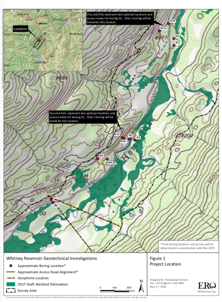
This map shows the location of test holes Homestake Partners plans to drill as part of its geotechnical investigation into the feasibility of a dam site in the Homestake Creek valley. The Forest Service has received more than 500 comments, most of them in opposition to, the drilling and the overall reservoir project. Photo by courtesy U.S. Forest Service.
Wilderness boundary
Even if the test drilling returns favorable results for a reservoir project, there is another obstacle that Homestake Partners will have to clear if they want to move forward with two iterations of the project: a wilderness-boundary change, which would require an act of Congress and the president’s signature.
The Whitney Reservoir alternatives range from 6,850 to 20,000 acre-feet and in some configurations would require federal legislation, which the cities are working to draft, requesting a boundary adjustment for the nearby Holy Cross Wilderness Area. The largest Whitney proposal would require an 80-acre adjustment, while an alternative location, lower down Homestake Creek, would require a 497-acre adjustment.
White River National Forest Supervisor Scott Fitzwilliams discounts the notion that his agency should reject outright the test-drilling application, as some environmental groups have suggested, until the wilderness-boundary issue is determined. Although some local and state lawmakers have said they are against shifting a wilderness boundary, Fitzwilliams said it’s still too soon for him to take up the wilderness issue.
“These are test holes,” Fitzwilliams said of the drilling, which is intended to see whether the substrata are solid enough for a dam and reservoir. “Going to get a (wilderness) boundary change is not a small deal for them, so why would you do it if you find fatal flaws? That’s a red herring.
“I understand it; nobody wants to see a dam in the Homestake drainage. I get that. But it just seems prudent to do (the drilling) to see if there’s any reason to go further.”
Aspen Journalism is collaborating with the Vail Daily and other Swift Communications newspapers on coverage of water and rivers. This story was published online by the Vail Daily on July 9, 2020 and in its print edition on July 10. The early online version of the story was edited to clarify aspects of the Eagle River MOU.
This story was published by Aspen Journalism on July 10, 2020.
This story was supported by The Water Desk using funding from the Walton Family Foundation.
Forty years after the Holy Cross Wilderness Area was created, an early effort to explore tapping its water supplies has generated more than 500 comments to the U.S. Forest Service.
Aurora and Colorado Springs, which own and operate the only reservoir in the area, Homestake I, hope to demonstrate that they can divert more water and build another reservoir to serve Front Range and West Slope interests without damaging the delicate wetlands and streams in the mountain forests there.
But first, they are asking the Forest Service for a special use permit to survey the area and to bore several test holes to determine soil conditions and areas best suited to build the proposed Whitney Reservoir. The public comment period closed June 30, although the Forest Service said it will continue to accept comments.
If a reservoir were to be built, it would also require that the 122,000-acre-plus wilderness area shrink by 500 acres, an action that will require congressional approval.
Significant opposition to the permit request is already building, with the Holy Cross Wilderness Defense Fund threatening legal action to stop the surveying and drilling of test holes into soils, according to comments submitted to the Forest Service.
Also opposing the process, among others, is Colorado state Sen. Kerry Donovan, who represents several West Slope counties. “Our wilderness areas are afforded the highest levels of protection and to begin action that disturbs them today begins a process of destroying them forever,” she said. [Editor’s note: Donovan is on the Board of Trustees of Water Education Colorado, which sponsors Fresh Water News].
In addition, she wrote, “With drought conditions becoming the new normal…it is imperative we protect high altitude water resources and keep each drop in the basin it was born in.”
The Eagle River is a tributary to the drought-stressed Colorado River, whose flows have already begun a serious decline.
Jerry Mallet is president of Colorado Headwaters, an environmental advocacy group. The fight to stop the proposal, he said, “will be as big as the Two Forks fight was several years ago,” referring to the successful effort to stop Two Forks Reservoir from being built on the South Platte River in 1990.
Aurora and Colorado Springs point to their legal obligations to develop a project that serves multiple interests, and which also protects the environment, while ensuring their citizens have access to water in the future.
“The studies…will provide the factual data necessary to identify and evaluate feasible reservoir alternatives to provide critical water supplies for human and environmental purposes,” said Colorado Springs spokesperson Natalie Eckhart. “We recognize the necessity to partner with other agencies throughout this process and are committed to working collaboratively with other communities and agencies to best manage our shared water resources.”
The proposal comes under a 1998 agreement known as the Eagle River Memorandum of Understanding, which allows the reservoir proponents to develop enough water to serve environmental, municipal and industrial interests. Aurora and Colorado Springs hope to develop 33,000 acre-feet of water, an amount roughly equal to that used annually by 66,000 homes.
Under the proposal, Aurora and Colorado Springs would receive 20,000 acre-feet, West Slope interests would receive 10,000 acre-feet, and 3,000 acre-feet would be set aside for the Climax Molybdenum Company.
Parties to the 1998 agreement include Aurora, Colorado Springs, the Colorado River District, the Eagle River Water and Sanitation District, the Upper Eagle River Water and Sanitation District, as well as Vail Associates.
Diane Johnson, spokesperson for the two Eagle River districts, said the agencies haven’t yet taken a position on the proposal, citing the need for the analysis required for the special use permit as well as any actual construction of a reservoir to be completed.
Located west of Vail between Minturn and Leadville, the Holy Cross Wilderness Area was the subject of a significant battle in the 1980s when Aurora and Colorado Springs sought to build a second major reservoir there known as Homestake II.
After opponents successfully took their case all the way to the U.S. Supreme Court, Homestake II was defeated in 1994.
In exchange, however, the cities were granted permission to develop a smaller amount of water in the future in partnership with Western Slope interests, resulting in the project that is now being proposed to the Forest Service.
To submit your comments or to get more information about the survey and drilling proposal, visit this U.S. Forest Service’s web page.
Jerd Smith is editor of Fresh Water News. She can be reached at 720-398-6474, via email at jerd@wateredco.org or @jerd_smith.
Fresh Water News is an independent, nonpartisan news initiative of Water Education Colorado. WEco is funded by multiple donors. Our editorial policy and donor list can be viewed at wateredco.org
This story originally appeared on Fresh Water News on July 8, 2020.